


وصف لـ Természetjáró, a túratervező
The online tourist guide of Hungary, specially developed for hikers, bikers and water sports lovers, featuring a built-in tour planner, as well as hundreds of recommended tours and thousands of POIs, all with detailed descriptions and plenty of photographs, comfortably viewable on an interactive map.
Features
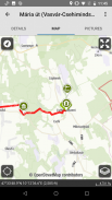
• Interactive, zoomable map with all the marked trails, showing your current position
• A convenient way to plan your own tour on the map, and get length, duration and elevation profile immediately
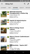
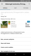
• Hundreds of recommended tours for hikers, bikers and canoers, with practical data, detailed description of the best sights nearby, natural and cultural background, good quality photographs and information on how to get there
• The complete Hungarian Blue Tour, with official sections and route, POIs and accomodations
• Offline map download
• On-the-fly navigation along the route, optionally with voice instructions
• Record your route
• Thousands of recommended sights, including lookout towers, natural panorama points, forest trains, fortresses and museums, with detailed description, good quality photographs, plus information on how to get there
• Hundreds of accomodations, including huts, tourist hotels and apartments, near marked trails
• List of places accepting TEKA (a special tourist card that provides discount for hikers in museums, accomodations, on the train etc.)
• Synchronise all your content between computer and mobile devices running the app
• Create your own lists of your favourite tours and POIs
• Check the weather forecast
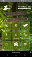
• Useful tools built in, such as peak finder, compass, inclinometer and QR-code reader
• Emergency phone call function right from the app, with your current position provided
• List every content by distance from you
• Community services: rate and share contents with your friends
Please note that our contents are changed and upgraded on a daily basis.
Attention: Continued use of GPS running in the background can dramatically decrease battery life.
Our desktop version:
https://www.termeszetjaro.hu/hu/
Follow us on Facebook:
https://www.facebook.com/Termeszetjaro.hu/
Contact us:
info@termeszetjaro.hu
More about the TEKA card:
http://www.termeszetjarokartya.hu/
دليل المجر السياحي عبر الإنترنت ، والذي تم تطويره خصيصًا لمحبي المشي لمسافات طويلة ومحبي الدراجات ومحبي الرياضات المائية ، ويضم مخطط رحلات مدمجًا ، بالإضافة إلى المئات من الجولات الموصى بها والآلاف من النقاط المهمة ، جميعها مع وصف تفصيلي والكثير من الصور الفوتوغرافية التي يمكن مشاهدتها بسهولة خريطة تفاعلية.
الميزات
• خريطة تفاعلية ، زومبية مع جميع المسارات المحددة ، والتي تعرض موقعك الحالي
• طريقة ملائمة للتخطيط لجولتك الخاصة على الخريطة ، والحصول على الطول والمدة وملف تعريف الارتفاع على الفور
• المئات من الجولات الموصى بها للمتجولين وراكبي الدراجات والكنو ، مع بيانات عملية وصف تفصيلي لأفضل المواقع القريبة والخلفية الطبيعية والثقافية والصور الفوتوغرافية ذات الجودة الجيدة والمعلومات حول كيفية الوصول إلى هناك
• جولة بلو هنغارية كاملة ، مع أقسام ومسارات رسمية ، ونقاط الاهتمام وأماكن الإقامة
• تنزيل الخريطة بلا اتصال
• التنقل على أثناء التنقل على طول المسار ، اختياريًا مع التعليمات الصوتية
• سجّل مسارك
• الآلاف من المعالم الموصى بها ، بما في ذلك أبراج المراقبة ونقاط البانوراما الطبيعية وقطارات الغابات والقلاع والمتاحف ، مع وصف تفصيلي وصور فوتوغرافية ذات جودة جيدة ، بالإضافة إلى معلومات حول كيفية الوصول إلى هناك
• مئات من أماكن الإقامة ، بما في ذلك الأكواخ والفنادق السياحية والشقق ، بالقرب من مسارات ملحوظة
• قائمة الأماكن التي تقبل TEKA (بطاقة سياحية خاصة تقدم خصمًا للمتجولين في المتاحف وأماكن الإقامة في القطار وما إلى ذلك)
• مزامنة كل المحتوى الخاص بك بين الكمبيوتر وأجهزة الجوال التي تقوم بتشغيل التطبيق
• إنشاء قوائم خاصة بك للجولات المفضلة لديك والنقاط المهمة
• تحقق من توقعات الطقس
• أدوات مفيدة مضمنة ، مثل جهاز البحث عن الذروة ، والبوصلة ، والميل الميل و قارئ رمز الاستجابة السريعة
• وظيفة مكالمة هاتفية عاجلة تعمل مباشرة من التطبيق ، مع توفير موقعك الحالي
• قائمة كل محتوى من خلال المسافة منك
• خدمات المجتمع: معدل ومشاركة المحتويات مع أصدقائك
يرجى ملاحظة أن محتوياتنا تتغير ويتم ترقيتها على أساس يومي.
انتباه: يمكن أن يؤدي استمرار استخدام GPS قيد التشغيل في الخلفية إلى تقليل عمر البطارية بشكل كبير.
إصدار سطح المكتب لدينا:
https://www.termeszetjaro.hu/hu/
تابعنا على Facebook:
https://www.facebook.com/Termeszetjaro.hu/
اتصل بنا:
info@termeszetjaro.hu
المزيد حول بطاقة TEKA:
http://www.termeszetjarokartya.hu/
The online tourist guide of Hungary, specially developed for hikers, bikers and water sports lovers, featuring a built-in tour planner, as well as hundreds of recommended tours and thousands of POIs, all with detailed descriptions and plenty of photographs, comfortably viewable on an interactive map.
Features
• Interactive, zoomable map with all the marked trails, showing your current position
• A convenient way to plan your own tour on the map, and get length, duration and elevation profile immediately
• Hundreds of recommended tours for hikers, bikers and canoers, with practical data, detailed description of the best sights nearby, natural and cultural background, good quality photographs and information on how to get there
• The complete Hungarian Blue Tour, with official sections and route, POIs and accomodations
• Offline map download
• On-the-fly navigation along the route, optionally with voice instructions
• Record your route
• Thousands of recommended sights, including lookout towers, natural panorama points, forest trains, fortresses and museums, with detailed description, good quality photographs, plus information on how to get there
• Hundreds of accomodations, including huts, tourist hotels and apartments, near marked trails
• List of places accepting TEKA (a special tourist card that provides discount for hikers in museums, accomodations, on the train etc.)
• Synchronise all your content between computer and mobile devices running the app
• Create your own lists of your favourite tours and POIs
• Check the weather forecast
• Useful tools built in, such as peak finder, compass, inclinometer and QR-code reader
• Emergency phone call function right from the app, with your current position provided
• List every content by distance from you
• Community services: rate and share contents with your friends
Please note that our contents are changed and upgraded on a daily basis.
Attention: Continued use of GPS running in the background can dramatically decrease battery life.
Our desktop version:
https://www.termeszetjaro.hu/hu/
Follow us on Facebook:
https://www.facebook.com/Termeszetjaro.hu/
Contact us:
info@termeszetjaro.hu
More about the TEKA card:
http://www.termeszetjarokartya.hu/
Természetjáró, a túratervező - معلومات APK
نُسخة APK: 3.14.9الحزمة: com.outdooractive.mtszتطبيقات من الفئة نفسها
قد يعجبك أيضًا...


